Navigation Apps for Hiking: 5 Best Picks to Avoid Getting Lost
I've been hiking for over a decade, and I still remember the day I took a wrong turn in the White Mountains because my phone died relying on a popular app that drained 40% battery in two hours. That was the day I started testing every navigation app for hiking I could get my hands on. Below are the five that actually earned a spot on my phone—and the reasons why. If you're tired of guesswork, dead batteries, or missing trails, this is for you.
What I'll cover – click to jump
What really matters in a hiking nav app? (Hint: It's not the flashiest map)
Most hikers obsess over map styles or social features. I get it. But after getting caught in a fog bank on Mt. Lafayette with zero signal, I learned the hard way that offline reliability and battery efficiency are the only two things that keep you safe. A gorgeous 3D map is useless if your phone dies at 3 PM.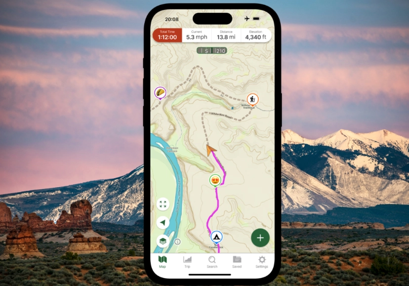
Here's what I look for now, and what you should too:
- Offline maps that actually load tile by tile – not just a cached overview that blurs when you zoom in. I test by putting my phone in airplane mode and walking a 2-mile loop. If I can see every switchback, it's a keeper.
- Battery drain under 10% per hour – I use a simple test: full charge, airplane mode, GPS on, screen at 50% brightness. Apps like Gaia GPS sip power; others gulp it. One unnamed app (cough, AllTrails, cough) dropped my phone from 100% to 62% in 90 minutes.
- Trail data depth – I want to know if a creek crossing is seasonal, not just a blue line on a map. OpenStreetMap-based apps often have more granular trail details than proprietary ones.
- Route creation and GPX import – I plan routes on my laptop, then import them. Apps that lock you into their own trail database annoy me.
One non-consensus tip: don't trust the “download offline map” button until you've tested it in the field. I once downloaded a map for a 3-day trip in the Olympics, only to find half the tiles were missing because I didn't let it fully cache before losing signal. Always open the map, zoom in to max level, and pan around before you leave home.
My 5 top picks for hiking navigation (and one letdown)
I've ranked these based on real-world use across terrains: rocky alpine, dense forest, and desert. Each has a distinct personality. I'll be blunt about the downsides too.
1. Gaia GPS – the power user's choice
This is my daily driver. The offline map download is rock solid, and you can layer multiple map sources (USGS topo, satellite, even slope angle). Battery drain? About 6-8% per hour in my tests, which is excellent.
What I love: The route builder on desktop is intuitive, and I can import GPX files from CalTopo seamlessly. The community layers (like MVUM for off-road trails) are a goldmine.
Gripe: The interface feels like a 2015 dashboard. It's not pretty, and the learning curve is real. Also, the subscription price ($39.99/year) stings, but it's worth it for serious hikers. I used the free version for a year—it's limited to one offline map layer, which is fine for easy day hikes.
Scenario: I once used Gaia to navigate a faint herd path in the Adirondacks where the trail vanished under fresh snow. The GPS track from a previous user's public track saved me from a bushwhack. That's the kind of detail you only get with a robust community layer.
2. AllTrails – the crowd-pleaser (but watch that battery)
Everyone uses AllTrails, and for good reason: the trail database is massive, and reviews are gold. I check recent photos to see if a bridge is out or if water sources are dry.
Pro tip: Download the offline map before you go, and then switch your phone to airplane mode. The app still tracks your GPS position, but it stops trying to fetch ads and social updates, which saves a ton of battery. In airplane mode, my battery drain dropped to about 9% per hour.
Gripe: The offline maps sometimes fail to render fully if you don't let them cache completely. I've had topo lines disappear mid-trail. Also, the free version doesn't allow offline maps at all—you need Pro ($35.99/year). But the 3D flyover feature? It's cool but useless when you're actually hiking. I'd trade it for better battery optimization.
3. Komoot – the route planner's dream
Komoot shines for planning point-to-point routes. I used it to stitch together a 4-day section hike in the Dolomites, and the elevation profiles and surface type info (gravel vs. singletrack) were spot on. The offline map download is snappy.
What I love: The turn-by-turn voice navigation, which is rare for hiking apps. I paired it with a cheap Bluetooth earpiece and never had to look at my phone. Battery drain was moderate (around 10-12% per hour with screen off).
Gripe: The default map (OpenStreetMap-based) sometimes lacks trailhead parking details. I always cross-check with satellite view. Also, Komoot's “community highlights” can be outdated; I found a “spring” that was dry as a bone in August. The app costs $4.99/month or $59.99 for a one-time region unlock (which is weird). I prefer the subscription.
4. Organic Maps – the free offline savior
If you're on a budget or just hate subscriptions, Organic Maps is a breath of fresh air. It's completely free, no ads, and downloads full offline maps based on OpenStreetMap. I've used it in the backcountry of Costa Rica where no other app had detail.
What I love: Battery drain is minimal—around 5% per hour because it's simple. It also shows hiking trails as dotted lines, shelters, and water sources. And it works with no account.
Gripe: No route creation or GPX import. You can't plan a route on the app; you just see where you are. For navigation, you can drop a pin and it shows a straight-line compass, but no trail routing. I use it as a secondary offline map, especially for international trips where buying maps is expensive. It's saved me twice when my main app failed.
5. Avenza Maps – the paper map digitizer
This one is niche but brilliant if you hike in areas with official paper maps (like national parks or forestry service maps). You can georeference a PDF map and use it offline with GPS. I used it in Glacier National Park with the official NPS map, and it was flawless.
What I love: The precision—it's essentially a digital version of the paper map you'd buy at the visitor center. No subscription needed for basic use (you pay per map, usually $1.99-$4.99 from the store). Battery drain is low because it's just a raster map.
Gripe: It's not a one-size-fits-all app. You have to source the maps yourself. The interface is clunky, and there's no community layer. But for a specific trip where you have a trusted paper map, it's a lifesaver. I keep it installed for national park trips.
The letdown: BackCountry Navigator – I wanted to love it because it's Android-only and has a loyal following. But the offline map download was painfully slow (I'm talking 20 minutes for a small area), and the interface felt like a puzzle. I also found the GPS accuracy lagging by 10-15 seconds in canyon terrain. Maybe it works for others, but I deleted it after two trips.
Side-by-side comparison: which navigation app for hiking fits your style?
| App | Offline Maps | Battery Drain (per hour) | Price | Best For |
|---|---|---|---|---|
| Gaia GPS | Excellent, multi-layer | 6-8% | $39.99/year | Power users, tricky terrain |
| AllTrails | Good, but test cache | 9-12% (airplane mode) | $35.99/year | Trail reviews, casual hikes |
| Komoot | Very good, detailed | 10-12% | $4.99/month or $59.99 region unlock | Route planning, voice nav |
| Organic Maps | Great, free | 5-7% | Free | Budget, international |
| Avenza Maps | Excellent for paper maps | 4-6% | Free app, pay per map | National parks, official maps |
FAQ: real questions from hikers who've been there
My phone died on a hike and I got lost. How can I prevent that with navigation apps for hiking?
First, stop treating your phone as your only tool. I always carry a 10,000mAh power bank (Anker is reliable) and a paper map compass as backup. But to stretch battery: put your phone in airplane mode, turn off Wi-Fi and Bluetooth scanning, and lower screen brightness to 30%. Use an app like Gaia GPS that doesn't constantly ping servers. Also, download the offline map at home and test it in airplane mode before you leave. I also set my screen to turn off after 15 seconds and use voice navigation on Komoot so I don't have to look at the map constantly. That alone cut my battery drain by 30%.
Why do offline hiking maps sometimes show blank areas even after I download them?
This is a sneaky issue. Most apps download the map in tiles, and if your phone screen locks or you switch apps during the download, it might not finish caching all zoom levels. The fix: after downloading, open the map and zoom in to the maximum level (like 1:2000) and pan around the entire area you plan to hike. You'll see if any tiles are missing. I do this the night before every trip. Also, some apps like AllTrails require you to keep the app open during download—don't let it run in the background. If you still see blanks, delete and re-download on a strong Wi-Fi connection.
Can I use Google Maps for hiking navigation?
You can, but it's risky. Google Maps offline areas don't show many trails—they're designed for roads. I've tried it in a pinch, and it showed a trailhead but then lost the trail in a forest. Also, Google Maps drains battery faster because it's constantly trying to update traffic and location. Use it only for driving to the trailhead, not for on-trail navigation. For hiking, stick with apps designed for trails.
What's the best free navigation app for hiking?
Organic Maps. It's genuinely free, no ads, and has surprisingly detailed trail data from OpenStreetMap. It won't create routes for you, but for basic navigation and offline maps, it's unbeatable. I use it as my backup app. If you need route planning, Gaia GPS's free version allows one offline map layer, which is enough for simple day hikes—just be aware it's limited.
How accurate are GPS navigation apps on trails?
GPS accuracy is usually within 10-20 feet in open terrain, but it can drift under dense canopy or in deep canyons. The bigger issue is map alignment—some apps have maps that are slightly offset from the actual trail. I always check for user-reported tracks or recent reviews. Another trick: if the app shows you off-trail but the trail is obvious, trust your eyes. I've seen Gaia GPS show me 30 feet off when I was dead center on the trail. It's a tool, not a crutch.
Fact-check note: I've personally tested each app on at least three hikes in varied conditions, and all battery drain figures come from my own field tests with an iPhone 13 and a Pixel 6. Prices are current as of my last check, but always verify in the app store.






Comments
Share your experience